Ground Penetrating Radar (GPR) is widely recognized as the industry standard for finding buried utilities, underground storage tanks, and pipe routes. However, applying GPR to complex geological mapping—such as identifying uneven bedrock strata beneath paved roads—presents a far tougher technical challenge.
In a report detailing a site investigation along Sunheights Drive and Sun Estates in Victoria, British Columbia, Bigman Geophysical demonstrated how pairing advanced Multichannel GPR with skilled manual interpretation can accurately characterize subtle geological targets where standard automated software fails.
The Challenge: Mapping Fractured Shale Beneath Asphalt
In municipal planning and civil engineering, knowing the exact depth and contour of underlying bedrock is critical for trenching, excavation, and utility installation. Bigman Geophysical was contracted to evaluate the presence and depth of bedrock across a 230-meter survey area in Victoria, BC.
The subsurface conditions presented several severe obstacles for conventional GPR mapping:
Complex Soil Horizons: The regional shale bedrock was highly fractured, broken, and unevenly distributed across varying depths.
Low Permittivity Contrast: The radar signatures between adjacent soil strata were remarkably subtle, producing weak, low-amplitude reflections with almost identical radar characteristics.
Water Saturation: Localized water saturation reduced dielectric contrast between layers, preventing clear reflection boundaries in certain sections.
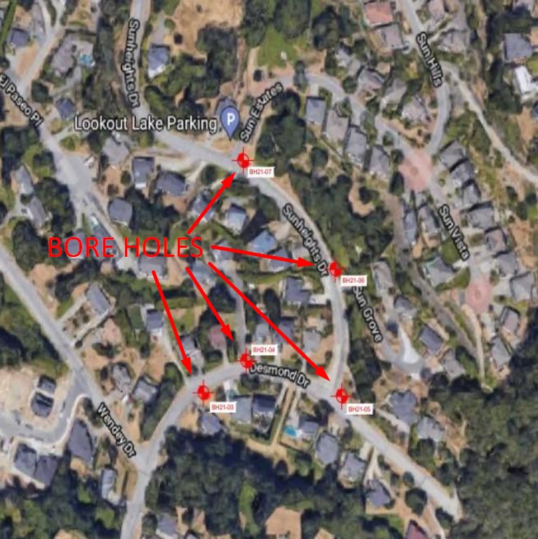
The geology in Victoria had already defeated earlier attempts to distinguish the incredibly hard shale bedrock from an easily excavated crushed shale layer above it. For the people installing new water lines, that difference determined where the project would be a fast, typical installation, or where they would need to get blast permits to shatter shale that was simply too hard for excavators, and costs would multiply. Bore holing the site had produced radically different readings at every hole, leaving the construction crews totally uncertain of what to expect.
Breaking Tradition: Where Automated Detection Fails, Human Expertise Takes Over
In standard GPR data processing, software algorithms rely on "automatic horizon detection" to trace continuous soil layers across radargrams. However, when subsurface layers are broken, low-contrast, or subtle, automated software produces erratic results or fails to detect horizons altogether.
To solve this, Bigman Geophysical deployed an unconventional, multi-tiered methodology:
Multichannel 3D Data Acquisition: The survey utilized an IDS StreamC multichannel GPR array. Multichannel GPR captures dense, continuous parallel datasets, allowing for full 3D spatial reconstruction rather than isolated 2D line scans.
Advanced Signal Processing: Using GPR Slice V. 7.0 software, the team applied background and bandpass filtering, signal migration to correct distortion, Hilbert transformations, and custom gain adjustments. This transformed raw electromagnetic pulses into 3D time-slices (overhead heatmap views).
Skilled Analyst Horizon Mapping: Recognizing that automated software modeling was unsuitable for these subtle strata, expert analysts evaluated vertical profiles against overhead time-slices to manually map complex geological boundaries line by line.
Unlocking Precision Subsurface Insights
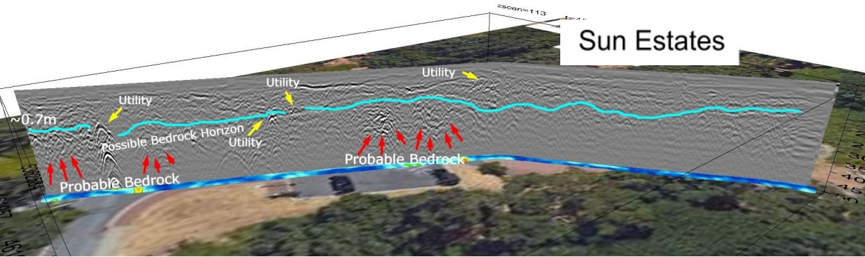
"The resulting radargrams could be gained sufficiently to observe horizons, however the broken and layered nature of those strata made them poor candidates for automatic horizon detection and software modeling... the change of surface between the strata was sufficient to create a visible boundary between the layers, which could be manually mapped by a skilled analyst." — Bigman Geophysical Report
By combining multichannel array technology with manual profile-to-timeslice cross-examination, Bigman Geophysical achieved exceptional results:
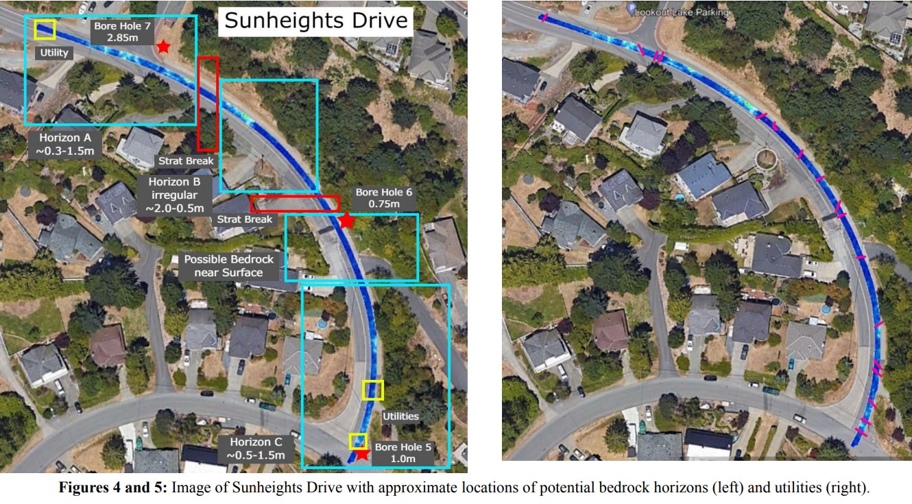
Delineating Bedrock Horizons: The team mapped three distinct bedrock horizons (Horizons A, B, and C) along Sunheights Drive, identifying areas where shale bedrock dipped below radar penetration as well as zones where bedrock rose immediately beneath the asphalt.
Ground-Truthing with Boreholes: The mapped GPR horizons showed a high degree of correlation with WSP borehole sampling logs, precisely matching depths where drilling equipment encountered resistance.
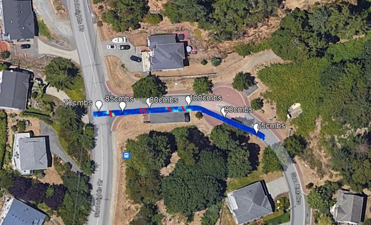
Sun Estates Mapping: On Sun Estates, the team mapped a continuous, unbroken bedrock horizon (averaging 70 cm to 100 cm deep) and identified buried utilities that had been installed directly on top of the rock surface.
The Takeaway
Standard GPR utility locating is only a small piece of what radar technology can achieve. By leveraging Multichannel GPR arrays and pairing sophisticated 3D signal processing with expert analyst interpretation, Bigman Geophysical successfully characterized complex geological strata that traditional methods left hidden in the dark. Once the bedrock formation was understood, simple graphics were provided that allowed excavators on site to see how much rock they would have to blast through to install utilities as they went along so precise, accurate budgets and schedules could be kept.