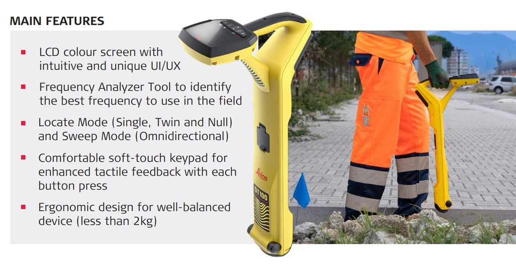
The Leica DT100 is an industry-leading, high-precision pipe and cable locator engineered to deliver absolute confidence in underground asset mapping. Designed for utility locators, surveyors, and civil construction contractors, the DT100 features intelligent digital signal processing and flexible tracking modes to map dense, complex underground networks with pinpoint accuracy.
When paired with the powerful Leica DE100 10-Watt Transmitter, the system cuts through background noise and signal bleeding, giving field operators real-time depth data and clear line tracing. From congested brownfield sites to highway utility surveys, the lightweight, rugged DT100 minimizes excavation risk, protects field teams, and streamlines your utility mapping workflows.
Key Features & Benefits
Intelligent Signal Processing & Multi-Target Resolution: Equipped with a wide-spectrum frequency range (50Hz to 200kHz), the DT100 separates closely spaced lines, minimizing bleed-off in high-congestion utility corridors.
On-Board Frequency Analyzer: Stop guessing field configurations. The integrated Frequency Analyzer tool scans the environment in real time to identify and select the cleanest, highest-performing active frequency for the site.
Effortless Dynamic Tracing (No Manual Leveling): The DT100's advanced multi-antenna arrays remove the need for perfect physical alignment. It accurately measures utility line depth and orientation even when held at slight angles.
Dual-Mapping Versatility (Locate & Sweep Modes): Alternate between passive Power and Radio sweeps for rapid hazard identification, or transition into high-precision Active peak/tri-axial modes using the DE100 signal generator for tracing targeted utility lines.
Built for Extended Field Shifts: At just 4.4 lbs (2 kg), the receiver features balanced ergonomics to prevent fatigue during long shifts. The dual-power compartment delivers up to 15 hours of continuous operation with a hot-swappable Li-Ion battery pack or fallback AA alkaline adapter.
GIS & Smart Mapping Ready: Seamlessly pairs with Leica Zeno Mobile One software and external smart antennas (like the Leica FLX100 Plus) for sub-meter or centimeter-level georeferenced GIS utility mapping and digital as-built data collection.
Technical Specifications
| Feature | Specification |
| Frequency Frequency Spectrum | 50Hz to 200kHz (Configurable Custom Frequencies) |
| Dynamic Range | 117 dB |
| Depth Accuracy | ±5% of depth (under undistorted conditions) |
| Operating Modes | Peak Mode, Tri-Axial Mode, Sweep Mode, Passive Radio/Power |
| Environmental Protection Rating | IP65 Dustproof & Waterproof |
| System Weight | Receiver: 2.0 kg (4.4 lbs) |
| Connectivity Ports | USB-C for fast firmware updates and diagnostics |
| Output Transmitter Power | Compatible with DE100 10-Watt multi-frequency transmitter |
Common Field Applications
Subsurface Utility Engineering (SUE): Map out unknown metallic conduits, pipes, and electrical lines prior to design phases or directional drilling.
Deep Asset Verification: Trace deep gas mains, water networks, and communication trunks accurately up to 3 meters (and beyond under optimal soil conditions).
Non-Conductive Duct Tracking: Pair with a structural Duct Hunter trace rod or Leica Sonde to easily chart plastic PVC lines, clay drains, and non-metallic storm sewer systems.
Excavation Clearing & Risk Mitigation: Perform rapid grid sweeps across commercial job sites to confirm utility layouts before trenching or post-hole digging.