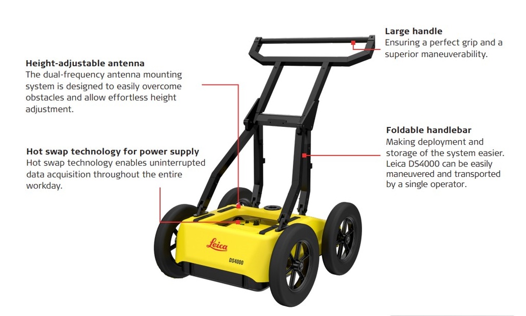
The Leica DS4000 is a next-generation, dual-antenna Ground Penetrating Radar (GPR) system engineered to redefine efficiency and precision in subsurface scanning and underground utility mapping. Designed for utility locators, surveyors, and civil engineering professionals, the DS4000 delivers up to 60% greater depth penetration and unmatched target resolution in complex urban and industrial environments.
Powered by Leica's patented EsT (Equalized scrambled Technology), this advanced cart-based system utilizes dual 200 MHz and 900 MHz central frequencies to cover an inspection range of 80 MHz to 1500 MHz. This allows operators to simultaneously capture shallow, high-detail infrastructure (like buried fiber optic cables or thin conduits) and deep assets (like gas mains or deep concrete pipes) in a single pass—eliminating the need for multiple scans and keeping project timelines on track.
Key Features & Benefits
Patented EsT (Equalized Scrambled Technology): Delivers peerless radar signal quality, boosting depth penetration by 40% to 60% compared to traditional GPR systems while reducing surface clutter and background noise.
Dual 200 MHz & 900 MHz Frequencies: Captures a comprehensive subsurface profile spanning an unmatched 80 MHz – 1500 MHz inspection range. Detect shallow assets and deep utilities simultaneously without changing antennas.
Ergonomic, Single-User Deployment: Weighing just 44 lbs (20 kg) with a modular, compact footprint and foldable handlebar, the DS4000 is perfectly designed for easy transport and rapid deployment by a single operator in tight spaces.
Real-Time On-Site Tomography: Pair with the rugged Leica CT1500 Field Tablet using uMap software to visualize live radar tomography (time slices), complete automatic calibrations, and digitalize anomalies right in the field.
Seamless Survey Integration: Fully compatible with external positioning systems, allowing effortless integration with GNSS/GPS receivers or Total Stations for millimeter-level georeferenced asset mapping.
Continuous Field Performance: Featuring hot-swappable battery technology and dual configuration capabilities to maintain uninterrupted data acquisition over long shifts.
Technical Specifications
| Feature | Specification |
| Number of Channels | 2 Hardware Channels |
| Central Frequencies | Dual 200 MHz (Deep) & 900 MHz (Shallow) |
| Inspection Spectrum Range | 80 MHz to 1500 MHz |
| Radar Signal Technology | Patented EsT (Equalized scrambled Technology) |
| Chassis Configuration | 4-Wheel modular cart with interchangeable airless off-road wheels |
| System Weight | 20 kg (44 lbs) |
| Environmental Protection | IP65 Weatherproof & dustproof |
| Polarization Configurations | Dual Horizontal-Horizontal (HH) & Vertical-Vertical (VV) |
| Post-Processing Compatibility | IQMaps Advanced 3D Processing with direct AutoCAD export |
Common Field Applications
Subsurface Utility Engineering (SUE): Safely map out buried utilities and locate threats before breaking ground to drastically minimize excavation risk.
Non-Conductive Utility Locating: Pinpoint critical fiber optic networks, PVC conduits, clay pipes, and concrete lines that traditional electromagnetic locators completely miss.
High-Congestion Urban Mapping: Resolve closely spaced utility lines and structural anomalies within dense, signal-heavy metropolitan layouts.
Geotechnical & Void Detection: Locate underground cavities, soil delamination, old storage tanks, and buried structural foundations.