Request A Quote
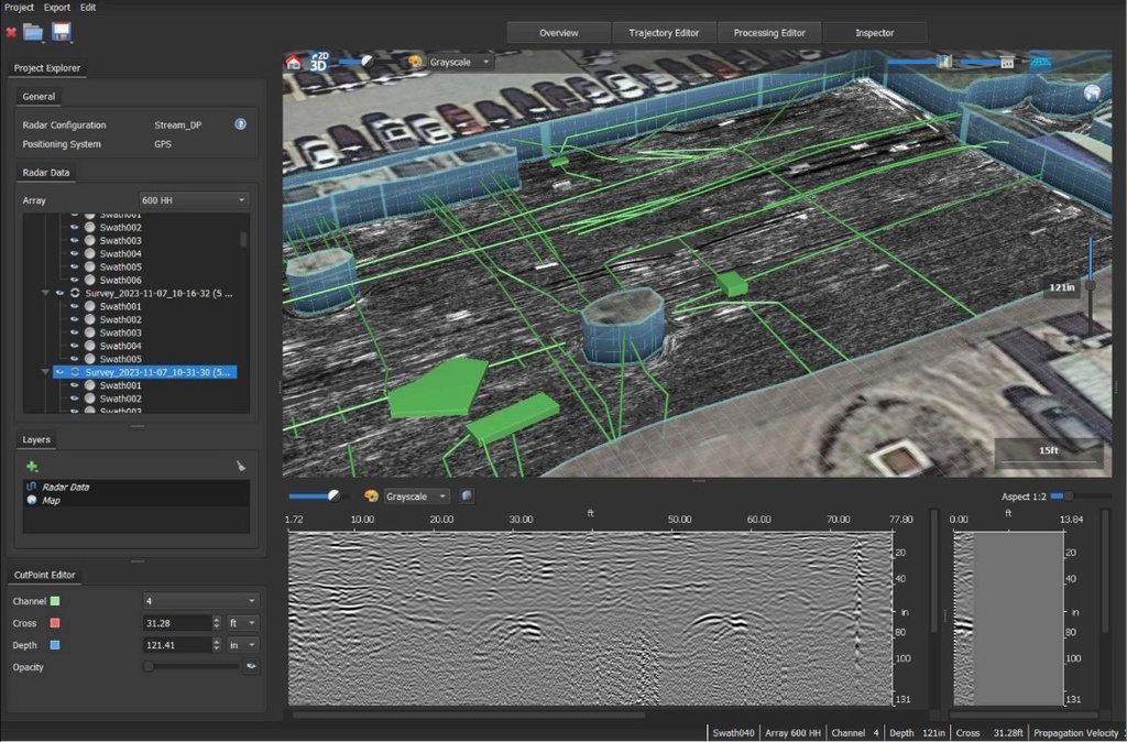
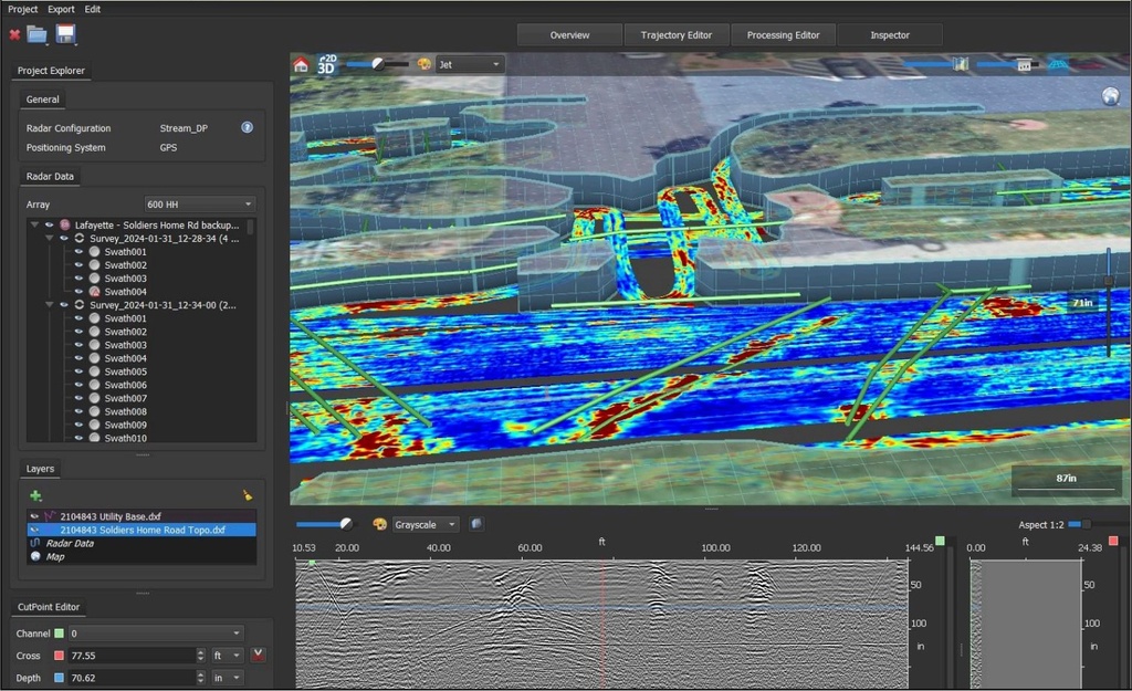
IQMaps is a new post-processing software application for advanced GPR data analysis, which provides a fast interfacing between the user and the GPR data. Machine time has been reduced and, contemporarily, real-time processing, advanced target management and 3D visualization have been introduced. In addition to underground assets detection and mapping, other functionalities are available for 3D mapping of sinkholes, inspection chambers and archaeological sites. IQMaps provides a step by step approach to guide the user in performing the best and the quickest data analysis with the help of a customizable processing and analysis tool, both for skilled and not skilled users for utility mapping, archaeological and environmental surveys and extensive mapping of large size projects.

IQMaps is available for Stream UP, Stream DP, Stream X, Chaser XR, Opera Duo, RIS MF Hi-Mod and Leica DSX, DS2000.
FEATURES AND BENEFITS
- Revolutionary interface
Allows an immersive reality during post-processing phase - Large areas acquisition
There is no limit in software use even for acquisition of large areas - User friendly
Ease of use and productivity have been dramatically increased (up to 30.000 sqm in a working day) - Georeferenced data
The new software has been developed with the precise aim to elaborate a georeferenced data after that it has been processed - Data easy to be managed
Intuitive interface with data ease to use and to be managed (scroll, pinch, spread) - Easy data extraction of various subsoil features
Anomaly detection (sinkholes, substations, buried objects) - Cloud Software Integration
Export, store, share and access data on major Cloud service providers for a streamlined workflow in utility detection
AI Maps Plugin
AiMaps 2.0 is the new cutting-edge tool for IQMaps pioneering the introduction of Artificial Intelligence in Underground Utility Detection and raising productivity to the next level with a straightforward cloud-based solution.
AiMaps 2.0 is a SaaS solution leveraging Artificial Intelligence for a new smart productivity in Utility surveying. AiMaps 2.0, fully integrated with the existing IDS GeoRadar IQMaps, exploits Hexagon’s HxDR platform for Reality Capture to run data processing on cloud for a resulting enhanced tomography of the utility network.
AiMaps 2.0 provides an intelligent view of underground utilities driving down time and workload in radar data processing and interpretation. With AiMaps 2.0 productivity is increased and cost savings are optimized by maximizing the underground capability detection: the underground utility analysis and extraction process can be improved with up to 70% cost savings.
AiMaps 2.0 provides intelligent radar data processing and interpretation to speed productivity while making GPR technology approachable to non-expert users. AiMaps 2.0 overcomes the complexity of radar data interpretation through deep learning algorithms that provide clean uncluttered data for a clear view of what lies beneath and allow a faster interpretation of hidden underground utilities.
FEATURES AND BENEFITS
- Raising productivity
Drives down time and workload in radar data processing and interpretation. Up to 70% cost savings in underground utility analysis and extraction process - Advanced cloud solution
Exploits Hexagon’s HxDR platform for Reality Capture to maximize underground utility detection capability - Overcoming complexity
Provides an intuitive and easy-to-use interface for professionals to perform data processing and interpretation - Fully integrated
Solution fully integrated with IQMaps, IDS GeoRadar's post-processing software application for advanced GPR data analysis