Overview Bigman Geophysical was recently brought in by Gravity Marine Consulting to conduct an interior geophysical investigation at an undisclosed location in Washington. The target? A freshwater cistern holding known to be leaking at a substantial rate. Our mission was to characterize the cistern floor, determine the concrete thickness, and locate any potential voids or anomalies contributing to the water loss.
The Challenge Operating inside a potable water cistern presents unique challenges. To prevent any risk of contaminating the freshwater supply, our team took rigorous safety precautions. All equipment was assembled on a clean tarp and sterilized with food-safe disinfectants before being lowered into the structure. During the investigation, nothing but the bottom of our inflatable vessel and the tow rope ever touched the water.
Additionally, during the data collection process, the testing of large electrical systems at the facility caused some signal interference. Despite the challenging electromagnetic environment, our advanced equipment and expert analysis allowed us to successfully gather the critical data needed for the project.
Bathymetry
Scans through 8 feet of water
Wall Scans
Tailored equipment for unusual applications
Our Approach and Methodology To image through the water’s surface—a technique known as bathymetry—as well as scan the sloped walls of the cistern down to the waterline, we utilized the IDS GeoRadar Chaser XR. This cutting-edge Ground Penetrating Radar (GPR) platform features equalized scramble technology, allowing dual-frequency (900 MHz and 200 MHz) antennas to penetrate deep into the subsurface while maintaining high-resolution imagery.
Using an inflatable vessel for the water-based scans and rope-deployed sleds for the dry, sloped walls, we carefully traversed the area. The data was then processed using Geolitix, an advanced software platform that uniquely allowed us to project both the bathymetric and wall scans simultaneously in 3D despite requiring totally different processing values.
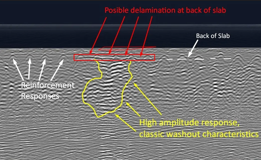
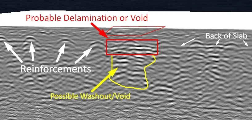
The Results The GPR survey yielded detailed insights into the cistern's subsurface environment. We were able to successfully verify the concrete slab thickness to be approximately 14 to 16 inches. More importantly, our analysis flagged four distinct subsurface anomalies that produced signal returns consistent with compromised materials, washouts, and leaks:
Targets of Concern A & B: These features presented an irregularly shaped horizontal response traveling along the bottom of the concrete slab, atop a larger, high-amplitude anomaly. This is a classic signature of water traveling just under a concrete slab, creating channels and sinkholes through erosion over time.
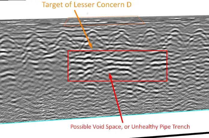
Targets of Lesser Concern C & D: Found on opposite sides of the cistern, these anomalies bear similar void-like characteristics but are associated with hyperbolic responses indicative of buried pipes. This suggests that water may be escaping primarily along the pipe trenches due to reduced soil compaction or localized pipe leaks.
Conclusion While non-destructive testing is part of a larger investigative process, the radar characteristics of these four anomalies provided strong evidence of subsurface voids. By pinpointing these exact locations, we provided our client with targeted areas for minimally invasive sample coring. This critical data will help determine the exact nature of the leak and guide the appropriate course of action to restore the cistern's integrity.
Precision Results
Targeted deliverables, clear interpretations.
At Bigman Geophysical, we pride ourselves on utilizing sensitive geophysical equipment and expert analysis to deliver confident, high-level results—even in the most challenging and unconventional environments!